Introduction
Background
By its decision 7/COP.13, the Conference of the Parties (COP) to the United Nations Convention to Combat Desertification (UNCCD) adopted the UNCCD 2018–2030 Strategic Framework, containing (a) five strategic objectives (SOs) and (b) an implementation framework. The SOs are:
SO1: To improve the condition of affected ecosystems, combat desertification/land degradation, promote sustainable land management and contribute to land degradation neutrality;
SO2: To improve the living conditions of affected populations;
SO3: To mitigate, adapt to, and manage the effects of drought in order to enhance resilience of vulnerable populations and ecosystems;
SO4: To generate global environmental benefits through effective implementation of the UNCCD; and
SO5: To mobilize substantial and additional financial and non-financial resources to support the implementation of the Convention by building effective partnerships at global and national level.
The implementation framework (IF) defines the roles and responsibilities of Parties and Convention institutions in meeting the SOs. Based on a comprehensive review of the IF reporting forms after the 2022 reporting process, it will not be presented as a stand-alone section in the 2026 national reporting cycle. Instead, its elements will be integrated into the appropriate sections under each Strategic Objective (SO). Internal consultations within the secretariat further identified potential overlaps between questions in the framework and the data required under individual SOs. Consequently, the three core components of the framework — Policy and Planning, Actions on the Ground, and Financial and Non-Financial Resources — have been reviewed and restructured to align with the most relevant SOs. Additionally, information on vulnerable and marginalized groups can be captured, where relevant, via reporting on the involvement of women, engagement of youth, and Indigenous Peoples and local communities. Parties can now find the respective section of the IF listed as an additional form under each SO with the form denoted with its respective SO number and ‘IF’ for Implementation Framework, e.g. the Implementation Framework form for SO1 is entitled ‘SO1-IF’.
Progress made in the implementation of the UNCCD 2018–2030 Strategic Framework has been regularly reviewed through the national reporting process since 2018. The reporting procedures, as well as the role and responsibilities of the Committee for the Review of the Implementation of the Convention (CRIC) in reviewing the reports, are spelled out in decisions 13/COP.13 and 15/COP.13.
Purpose of national reporting
Information reported by Parties under the Convention is used in several ways. It is employed to monitor progress towards achieving SDG target 15.3 and to help guide policy formulation at the national and international level to combat desertification/land degradation and drought (DLDD). The information helps policymakers to better understand the geographical areas that are most affected in their countries and allows more targeted measures and interventions to be designed and implemented. A number of countries have leveraged the data and information provided in the latest round of reporting (2022) to produce national action plans to address land degradation or used some of the material as part of project proposals to seek national and international funding to implement concrete actions on the ground. Comprehensive reports by Parties provide practical demonstrations of how to optimise the reporting and implement on the ground interventions while motivating other Parties and build understanding of successes and challenges in implementing the Convention. Finally, the reported information plays an important role in raising awareness of the importance of sustainable land management and advocating for land restoration initiatives that can help combat DLDD and their impacts on populations. In a nutshell, national reporting puts data and information on land to good use.
Indicator and monitoring framework
The UNCCD indicator and monitoring framework has a hierarchical structure that makes it possible to distinguish what to measure (progress indicators) and how it should be measured (metrics/proxies).
Indicators used for reporting on progress towards the SOs are those adopted by Parties in decision 7/COP.13, 9/COP.13, 11/COP.14 and 4/COP.16. Table 1 through Table 5 below contain an overview of the indicators, their related metrics/proxies, the decisions in which they have been adopted, and the reporting attributions (i.e., whether the indicators are required or optional for reporting by affected and developed country Parties). While some indicators are marked as not applicable for developed country Parties, each developed country Party may choose whether to report on them or not. If a developed country Party decides to report on an indicator marked as not applicable, it can do so by changing the indicator form’s status from ‘not applicable’ to ‘open’ in PRAIS.
Reporting on the implementation framework is done through qualitative information, largely by narratives on national experiences, and on a voluntary basis.
Indicator code |
Indicator name |
Metrics / proxies |
Adoption Decision |
Reporting attribution |
|
|---|---|---|---|---|---|
Affected country Parties |
Developed country Parties |
||||
SO 1-1 |
Trends in land cover |
Land cover change |
7/COP.13 |
Required |
Optional. Developed country Parties may wish to submit information on SO1 indicators, including SDG indicator 15.3.1, on a voluntary basis for the purpose of reporting on progress towards the SDGs. |
SO 1-2 |
Trends in land productivity or functioning of the land |
Land productivity dynamics |
7/COP.13 |
Required |
|
SO 1-3 |
Trends in carbon stocks above and below ground |
Soil organic carbon stock |
7/COP.13 |
Required |
|
SO 1-4 |
Proportion of land that is degraded over total land area |
— |
9/COP.13 |
Required |
|
Indicator code |
Indicator name |
Metrics / proxies |
Adoption Decision |
Reporting attribution |
|
|---|---|---|---|---|---|
Affected country Parties |
Developed country Parties |
||||
SO 2-1 |
Trends in population living below the relative poverty line and/or income inequality in affected areas |
Proportion of the population below the international poverty line OR Income inequality |
7/COP.13 |
Required |
Not applicable |
SO 2-2 |
Trends in access to safe drinking water in affected areas |
Proportion of population using safely managed drinking water services |
7/COP.13 |
Required |
Not applicable |
SO 2-3 |
Trends in the proportion of the population exposed to land degradation, disaggregated by sex |
Proportion of the population exposed to land degradation, disaggregated by sex |
4/COP.16 |
Optional |
Optional |
Indicator code |
Indicator name |
Metrics / proxies |
Adoption Decision |
Reporting attribution |
|
|---|---|---|---|---|---|
Affected country Parties |
Developed country Parties |
||||
SO 3-1 |
Trends in the proportion of land under drought over the total land area |
Proportion of land in each drought intensity class as defined by the Standardized Precipitation Index |
11/COP.14 |
Required |
Not applicable |
SO 3-2 |
Trends in the proportion of the total population exposed to drought |
Proportion of the population exposed to drought, disaggregated by sex |
11/COP.14 |
Required |
Not applicable |
SO 3-3 |
Trends in the degree of drought vulnerability |
Drought Vulnerability Index |
11/COP.14 |
Required |
Not applicable |
Indicator code |
Indicator name |
Metrics / proxies |
Adoption Decision / proposed |
Reporting attribution |
|
|---|---|---|---|---|---|
Affected country Parties |
Developed country Parties |
||||
SO 4-1 |
Trends in carbon stocks above and below ground |
Trends in carbon stocks above and below ground is a multipurpose indicator used to measure progress towards both strategic objectives 1 and 4. See progress indicator SO 1-3. |
|||
SO 4-2 |
Trends in abundance and distribution of selected species |
Red List Index |
7/COP.13 |
Required |
Not applicable |
SO 4-3 |
Trends in protected area coverage of important biodiversity areas |
Average proportion of Terrestrial Key Biodiversity Areas covered by protected areas |
4/COP.16 |
Optional |
Not applicable |
Indicator code |
Indicator name |
Metrics / proxies |
Adoption Decision |
Reporting attribution |
|
|---|---|---|---|---|---|
Affected country Parties |
Developed country Parties |
||||
SO 5-1 |
Bilateral and multilateral public resources |
— |
7/COP.13 [1] |
Required |
Required |
SO 5-2 |
Domestic public resources |
— |
7/COP.13 [2] |
Required |
Required |
SO 5-3 |
International and domestic private resources |
— |
4/COP.16 |
Optional |
Optional |
SO 5-4 |
Technology transfer |
— |
4/COP.16 |
Optional |
Optional |
SO 5-5 |
Future support for activities related to the implementation of the Convention |
— |
4/COP.16 |
Optional |
Optional |
Reporting tools
For the 2026 reporting process, the performance review and assessment of implementation system (PRAIS 4) has been further improved to facilitate the reporting process. The most significant changes are:
The Overview tab allows each Party to monitor the status of all their SO and indicators, and to track progress in completing the national report. By default, forms are labelled as either “open” or “not applicable”. If a Party wishes to report on an indicator marked as “not applicable” they can simply change the form status to “open” and enter the required information. Once a form is ready for quality assurance, the Party should change its status to “in review” to notify the secretariat. The review process is iterative: after resolving any comments posted during the review, the Party should resubmit the form by setting it to “in review” again. Once the Secretariat approves the form, its status should be updated to “Finalized” prior to the formal submission of SO1 and/or the overall report;
A specific tab entitled CP to capture Country Profile information including land area and population;
New functionality for SO1-1 to report one or more (max. five) regional land cover transition matrices which allow better capture of regional and local conditions;
Parties can now stratify the land productivity and soil organic carbon stock indicators using custom/national land cover classes as an alternative to the default UNCCD seven land cover classes;
The SO1 forms now also support the reporting of land improvement, in addition to land degradation, providing valuable insights in the context of achieving LDN;
Data on SDG indicators — excluding SDG indicator 15.3.1 — have been imported from the SDG Global Database as default data and synchronized with PRAIS to reduce the reporting burden and avoid duplication of data validation efforts;
The reporting forms have been simplified to the extent possible — for example, by removing non-essential tables and limiting reporting to key years necessary to capture the baseline and reporting periods;
Parties are encouraged to provide more narrative information and stories on their national and regional situations. Additional comment fields have been added after many of the tables under the indicators to facilitate this;
Geospatial information is now grouped by indicator making it easier to visualize raster layers that are relevant for each indicator reported. Geospatial information supporting indicator calculation is now dynamically linked to its respective reporting table such that if information reported in the table changes the geospatial information is automatically removed from the national report. In addition, transparency has been added to the spatial viewer to allow basemaps, such as high-resolution satellite imagery to be seen, underneath the geospatial layers used for reporting.
The following reporting tools will be made available to country Parties in the six official United Nations languages:
The updated PRAIS 4 user manual, which provides step-by-step procedures for system access and use;
This updated reporting manual, which provides step-by-step methodological guidance for the preparation of national reports;
An updated glossary of reporting terms and definitions included in this reporting manual;
A set of e-learning videos for each SO providing information on the reporting steps required;
A chat functionality, which is embedded in PRAIS and accessible to country Parties and UNCCD technical experts to facilitate communication among them in a less formal way. Discussion forums on topics relevant to national reporting will also be set up for all users of the PRAIS platform to exchange ideas and communicate with UNCCD technical experts. Users have the option to choose a language to use in the chat app.
In addition, Parties should also refer to the following methodological reference documents (in English only):
Version 2 of the Good Practice Guidance for SDG Indicator 15.3.1: Proportion of land that is degraded over total land area;
The Addendum to Version 2 of the Good Practice Guidance for SDG Indicator 15.3.1;
Good Practice Guidance for National Reporting on UNCCD Strategic Objective 3;
Good Practice Guidance for National Reporting on UNCCD Strategic Objective 5.
Furthermore, a report, entitled The Land Story (UNCCD, 2024) presents examples of best practices adopted by countries during the 2022 reporting cycle and is available for consultation.
Data analytics tools
In line with decision 4/COP.16, Conservation International has further enhanced Trends.Earth to address the critical technical issues raised by country Parties during the 2022 UNCCD reporting process. Trends.Earth has been upgraded to reflect the refinements contained in the Addendum to version 2 of the Good Practice Guidance for SDG Indicator 15.3.1. Further information on Trends.Earth functionality and updates can be found in the Trends.Earth documentation.
Default data
With a view to reducing the reporting burden and in accordance with the procedure established in decision 22/COP.11, the PRAIS 4 forms will be pre-filled with default national estimates based on available global data sources. Country Parties will have the possibility to verify or replace these national estimates using other datasets sourced/computed nationally/locally.
For reporting on indicators related to SO1, SO2 or SO3, countries wishing to replace the default national estimates using nationally or locally available data are advised and encouraged to use Trends.Earth for the preparation, analysis and transfer of their data into PRAIS. Other tools may also be used for data preparation if preferred as long as the methodology used is consistent with the Good Practice Guidance document on SDG Indicator 15.3.1 and its Addendum and the outputs are compatible with the requirements for upload to PRAIS.
For reporting on indicators related to SO5, default data is also provided in a set of Excel files. Parties are requested to download these files and verify the activity-level default data provided therein. Further details on validating the default data are provided in this manual in the chapter related to SO5 reporting.
National boundaries
In order to provide national-level extracts of the global data sources for national reporting, the United Nations Geospatial Hub (hereinafter referred to as UN Map Data) was used, which is a worldwide geospatial database consisting of country and geographic name information and a coherent alignment of national boundaries for consistent representation on a global scale. UN Map Data includes geospatial web services, which aim to provide a contextual global webservices background to the international community. The current flagship United Nations web map service is entitled Clear Map[3] (hereinafter referred to as UN Clear Map). UN Clear Map was originally designed and created for the use of the United Nations Secretariat and system for their website and related web products but is now a publicly available resource subject to the terms of use. The UN Clear Map service is available in PRAIS 4 in different cartographic styles and web canvases to give countries context for the geospatial reporting data. However, the UN Clear Map has scale constraints, as it cannot be used beyond a map scale of 1:4.5 million. Alternative web map services are provided for context at finer scales to compensate for the scale constraints of UN Clear Map.
The UN Clear Map Data has been prepared by the United Nations Geospatial Information Section (formerly Cartographic Section) in New York. The designations employed and the presentation of material contained in the UN Clear Map Data do not imply the expression of any opinion whatsoever on the part of the UNCCD concerning the legal status of any country, territory, city or area or of its authorities, or concerning the delimitation of its frontiers or boundaries.
For cartographic representation and preparation of the default data, PRAIS uses the international boundaries of countries taken from the United Nations Map 0 geodata which is suitable for 1:1 million scale representation and serves global mapping purposes as opposed to local mapping. Countries can opt to use an alternative country border by uploading the polygon directly to the PRAIS spatial data viewer. However, should Parties opt to use an alternative country boundary layer, they are encouraged to engage with the Second Administrative Level Boundaries (SALB) programme of the Geospatial Information Section & Statistics Division. The programme’s objective is to promote accessible, interoperable and global data and information on subnational units and boundaries. Participation in the programme will ensure Member States of the United Nations will avail of a global repository of authoritative information and geospatial data about the administrative unit structure of countries down to the second subnational level, and through time. Parties should engage with the SALB program directly by sending an email to salb@un.org.
Careful consideration should be given to the use of an alternative national border in that it must be consistent with the total land area reported under SO 1-1. Otherwise, discrepancies may arise in the reporting data derived from geospatial analysis using that border.
Open data sharing
By its decision 16/COP.11, the COP requested the secretariat to ensure that data and information from the reporting process are available and accessible to all, especially at the national and local levels. Decision 11/COP.14 requests the secretariat to further analyse and present global and regional data in interactive formats.
In order to maximize the interoperability and impact of data submitted by Parties and to allow the secretariat to make regional and global aggregate information from the national reports, all Parties are encouraged to openly license nationally reported data under either the Creative Commons Universal Public Domain Dedication 1.0 (CC0), or the most open Creative Commons Attribution 4.0 International (CC BY) licence.
The CC0 public domain dedication enables unrestricted reuse without the need for attribution, which can be especially useful for foundational datasets or where reuse by researchers or international agencies is a priority, as is typically the case for those datasets related to land cover and land degradation assessments.
The CC BY licence is the most open of the Creative Commons licenses, making it a fundamental legal tool for data interoperability and supporting broad reuse and adaptation. The CC BY licence only has one condition: attribution. When more licencing conditions are added, it becomes harder to combine data that uses other licences and control the licence of the resulting dataset, report, or product. The CC BY licence is also recognized by global data communities as a gold standard for maximized sharing, including across the UN system and as required by the European Commission’s requirement on high-value datasets.
By applying the CC0 public domain dedication or CC BY licences to national datasets:
Parties contribute to efficient, evidence-based policy and scientific cooperation at all levels;
Parties strengthen the global visibility and impact of their national work on land and sustainability;
Parties’ data can easily be reused by other agencies and organizations, including regional hubs, giving them most freedom of the licence they want to publish under;
Parties enable the seamless integration of their data into the UNCCD’s aggregate information products based on national reports such as those displayed on the UNCCD Data Dashboard (that is licensed as CC BY-NC).
These guidelines are designed to maximize the interoperability of submitted national data by clearly defining its conditions of reuse. Interoperability and synergies in information exchange between Conventions is only possible when data can be legally, confidently, and consistently reused across systems, which requires reuse conditions that are both explicit and standardized.
You can read more about the licences in Annex I of these guidelines and you can find comprehensive information at the Creative Commons website.
Taking the above guidelines into account, Parties have the option to fill out a User Specific Licence (USL) form in PRAIS and choose whether to: (i) use an existing Creative Commons licence; or (ii) opt for an exemption and select a custom licence.
It is important to note that most of the default datasets have been licensed by their respective data providers under a Creative Commons Attribution 4.0 International (CC BY 4.0) licence. Thus, these datasets are subject to the one condition of that licence: attribution. Users of these datasets, such as the UNCCD and its Parties, must therefore attribute the source of the licence if using these default datasets in their national report. For more information on the issue of data sharing and how to complete the USL form, see Annex I of this reporting manual.
Reporting frequency
By its decision 15/COP.13, the COP approved a four-year frequency for national reporting (Table 6).
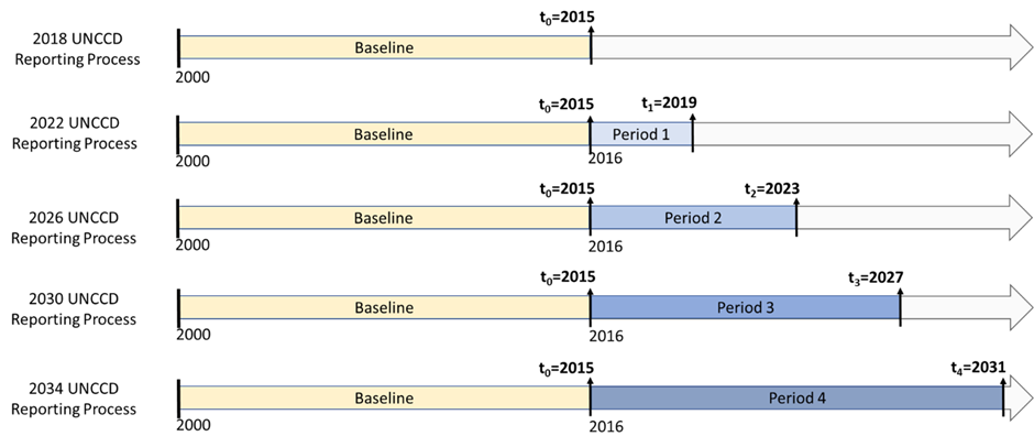
During the 2018 reporting process, Parties reported data and information for the period 2000–2015, which serves as the baseline for SDG indicator 15.3.1 and its sub-indicators. After this initial reporting, Parties continue to report the status of land condition and the SDG indicator 15.3.1 every four years, thereby increasing the reporting periods in four-year increments.
Figure 1 shows that the first reporting period (Period 1) completed in 2022, covered the timeframe from January 1st, 2016, to December 31st, 2019. The results of the Period 1 assessment included the estimation of the proportion of degraded land (SDG Indicator 15.3.1) for 2019 (t1). Subsequent reports will reflect the land condition at the end of 2023 (t2), 2027 (t3) and, potentially, 2031 (t4), integrating changes that have occurred since the end of the baseline period (from January 1st, 2016). Therefore the reporting is incremental in time, each reporting period incorporating four additional years compared to the previous one.
Figure 1. Timeline illustrating the four-year UNCCD reporting frequency for SDG indicator 15.3.1
UNCCD Reporting Process |
UNCCD Reporting Periods |
|---|---|
2018 |
Baseline 2000-2015 |
2022 |
2016-2019 |
2026 |
2016-2023 |
2030 |
2016-2027 |
2034 |
2016-2031 |
Recalculations and time series consistency
Advances in methodologies and data availability may require periodic recalculations of previously submitted national estimates. While recalculations may require refinements in terms of target-setting, they ensure the consistency of the time series and the comparability between the baseline and future monitoring data.
For instance, given the evolution of the calculation methods presented in version 2 of the Good Practice Guidance for SDG Indicator 15.3.1 and its Addendum, it is recommended that previously submitted estimates of all SO1 indicators, including SDG Indicator 15.3.1, be recalculated and included in the national report to be submitted in 2026. Default national estimates provided through the PRAIS forms have already been recalculated for country Parties using the new calculation methods.
For a broader discussion on the issue of recalculations, see chapter 6 of version 2 of the Good Practice Guidance for SDG Indicator 15.3.1.
Submission of the national report, validation and review process
Building on the experiences and lessons learned from the use of PRAIS in the 2022 reporting process, a next generation of the on-line platform was developed for the 2026 reporting process to improve data entry, review, communication and quality assurance functionalities. The design and upgrade of the platform was carried out bearing in mind the following objectives:
A) Quality Assurance - To ensure that national reports are comprehensive, internally consistent, aligned with UNCCD guidelines and well-integrated, the platform should implement robust validation rules. These rules serve as quality control mechanisms to verify the accuracy, completeness, and coherence of submitted data before it is used by the secretariat in aggregate reports and derivative information products.
B) Transparency – the platform should enable access to all the documentation necessary for understanding how the indicators should be reported, including explanations of key terms, the default data sources, definitions and the methodologies used.
C) Ease of use – the platform should have an intuitive interface with an overview country management dashboard, forms which allow easy data entry, switching between national and default data sources, and upload of other datasets and/or documentation.
D) Improved communication – the platform should have a transparent review and revision functionality, which allows tracking of changes in the reported figures and facilitates understanding of the review process flow.
E) Flexibility – the platform should clearly outline the differentiated reporting obligations of Affected Country Parties and Developed Country Parties, while allowing countries the flexibility to adjust the indicators they report—for example, by choosing to report on optional indicators or on indicators generally considered not applicable to their country category.
Once a reporting form has been completed and all the tables in that form have been filled in, the Reporting Officer can make the form available to the secretariat for review. This will lock the form so that no further editing can take place and allow the review process to begin. The review is carried out by the UNCCD secretariat, and is necessary to ensure that reported figures are consistent and that the reporting methodology is applied correctly. To make a form available for review, its status in the platform must be set to “In Review”. If during the review process the need for clarifications or amendments arises, the reviewers can insert feedback via comments and send back the form to the national reporting officer. The national reporting officer is notified when the review process is completed and if comments need to be addressed. The form will then be again set to “Open” mode and the reporting officer can address the comments and modify the report accordingly and resubmit it for another review cycle. When no further clarifications or amendments are required, the form is considered finalized and ready for the final submission to the secretariat.
Building on the lessons learned from the 2022 reporting process, a number of system validation rules have been implemented in PRAIS for 2026 reporting. These will appear as errors when users try to save the reporting form. Errors (arising from the application of system validation rules) appear on the forms to highlight any major discrepancies in reported data (see inter-tabular consistency paragraph below). The error message will help the user understand the issue and indicate to the user how to rectify the problem before being allowed to save the form.
Inter-tabular consistency: the total country area and demographics, as presented in the country profile (CP-1.T1 and CP-1.T2), constitute the basis for reporting in many of the other reporting tables. For inter-tabular consistency, the total country, land and water body area as well as total population must not be less than the corresponding area or population estimates in SO1, SO2-3, SO3-1 and SO3-2 tables. The system automatically prefills the total country, land and water body areas and national population in the country profile based on default data. If any reported degraded area, area under drought or populations exposed exceed the values reported in the country profile an error will appear since the percentage value reported cannot normally exceed 100%.
Having negative numbers in tables where only positive numbers are allowed or having non-numeric characters in numeric-only fields also trigger error messages. Regardless of what validation rule triggers the error, the error will prevent the saving of a form and must be rectified by the user before the form can be saved or submitted for review.
Process and schedule for the 2026 reporting process
The deadlines for submission of national reports are tentatively set for November 2026 for reporting on SO1, and February 2027 for the remaining SOs. The CRIC Bureau will monitor progress made throughout the 2026 reporting process to decide on adjustments to this timeline, if needed.
Various measures will be taken by the secretariat to support Parties in preparing the national reports and providing high quality information:
In-person regional capacity development activities will be organized. These aim to introduce national focal points and assigned reporting officers to the updated reporting requirements, methodologies, data and tools;
The secretariat and the Global Mechanism, with the assistance of consultants and/or regional institutions, will provide technical backstopping throughout the reporting process;
An online helpdesk facility, which can be accessed at https://support.unccd.int/ will be available via PRAIS to respond to queries from Parties;
A multi-lingual chat functionality, which is embedded in PRAIS and accessible to country Parties and UNCCD technical experts to facilitate communication among them in a less formal way,
National reports will undergo a quality assurance procedure prior to final submission to ensure the provision of consistent, transparent, comparable, accurate and complete information.
At its twenty-fifth session, the CRIC will review and analyse the information submitted during the 2026 reporting process.
Country profile
Information on the total country area, as well as its division into total land area and area covered by water bodies are prerequisites for the calculation of amount of degraded or improved land and other indicators. Information on national population size and its composition in terms of number of males and females is necessary for the calculation of a number of the indicators. This information is gathered in a Country Profile Form and the data is used by indicators with related dependencies.
Land Area
Note
Related areas in the PRAIS 4 platform: table CP-1.T1
Information on the total land area, area covered by water bodies, and total country area is required to calculate the proportion of land that is degraded over total land area (SDG indicator 15.3.1), but also to calculate indicators to track progress towards other SOs (e.g. SO 3-1: Trends in the proportion of land under drought over the total land area).
Total land area, total water bodies area and total country area require respective estimates to be reported in square kilometres (km2) for 2000, 2015, 2019 and 2023 or closest available years (to align with the initial and final years of the baseline and reporting periods for SDG indicator 15.3.1). Land area data is pre-filled in the reporting table CP-1.T1. Estimates are based on the default land cover data and, as such, they could differ from official national statistics. The pre-filled data can be changed by clicking on the ‘National Data’ switch above the table. However, it is important to ensure consistency with the land cover data and the SDG indicator 15.3.1 estimates. Parties should note that the total country area is auto-calculated in PRAIS from the addition of the total land area and water bodies and is therefore not an editable field.
Any changes to the default estimates are to be justified in the ‘Comments’ column or ´Comments´ field below the table.
Demographics
Note
Related areas in the PRAIS 4 platform: table CP-1.T2
Information on total population as well as number of females and males is important to understand the impacts of land degradation and drought, and their gender dimension.
If available, national estimates of the female, male, and total population on an annual basis since 2000 should be provided, expressed in thousands. Demographic data is pre-filled in the reporting table CP-1.T2 using data from the WorldPop dataset from 2000 to 2023. Parties should note that this dataset has not been updated for the 2026 reporting and therefore the final three years (2021, 2022, and 2023) duplicate values for 2020. Moreover it should be noted that while the School of Geography and Environmental Science at the University of Southampton (UK) has recently released a new global demographic dataset for 2015–2030, it was still in beta format at the time the 2026 reporting process was launched and will not be made available as default data. Beta versions of datasets can contain inconsistencies, errors or anomalies. As soon as this new global demographic dataset is formally published, Parties will be able to download it from Trends.Earth and import it to PRAIS 4 to replace the default data.
If better national estimates are available, the Parties should click on the “National Data” button and enter their own annual population estimates. However, it is important to ensure consistency with the data used to report the proportion of population exposure to land degradation and drought. Any changes are to be justified in the “Comments” field following the table.
A field for “General Comments” is also provided if any additional information or clarifications are to be provided in relation to the land area and demographics data provided.