6. Strategic objective 1 to 4: voluntary targets, additional indicators and affected areas
6.1. Voluntary targets for strategic objective 1
6.1.1. Introduction
Parties may wish to set national voluntary targets that contribute to strategic objective 1 (SO 1) and therefore “to improve the condition of affected ecosystems, combat desertification/land degradation, promote sustainable land management and contribute to Land Degradation Neutrality (LDN)”.
This includes, but is not limited to, the formulation and/or revision of LDN voluntary targets in accordance with Parties’ specific national circumstances and development priorities. LDN voluntary targets reflect Parties’ ambitions in achieving no net loss of (and thus neutrality), or gains in, healthy and productive land when compared to the baseline.
The definition and/or revision of voluntary targets should be based on best available data and knowledge. The assessment of land degradation and its drivers plays a key role in informing the decision-making process. Relevant stakeholders must be involved in the voluntary target definition/revision process to ensure ownership and that the achievement of LDN does not come at the expense of adverse social and ecosystem impacts. Specific consideration should be given to ensuring full engagement of people in vulnerable situations, including Indigenous Peoples and local communities, and gender balance through the equitable representation of men and women.
Targets need to be measurable to monitor progress. Parties are invited to formulate specific, quantitative, spatially explicit and time-bound voluntary targets aiming at achieving a neutral (no net loss) or improved (net gain) state of the land, and defining interventions that contribute to avoiding, reducing and reversing land degradation, in line with the LDN response hierarchy (see figure 9).
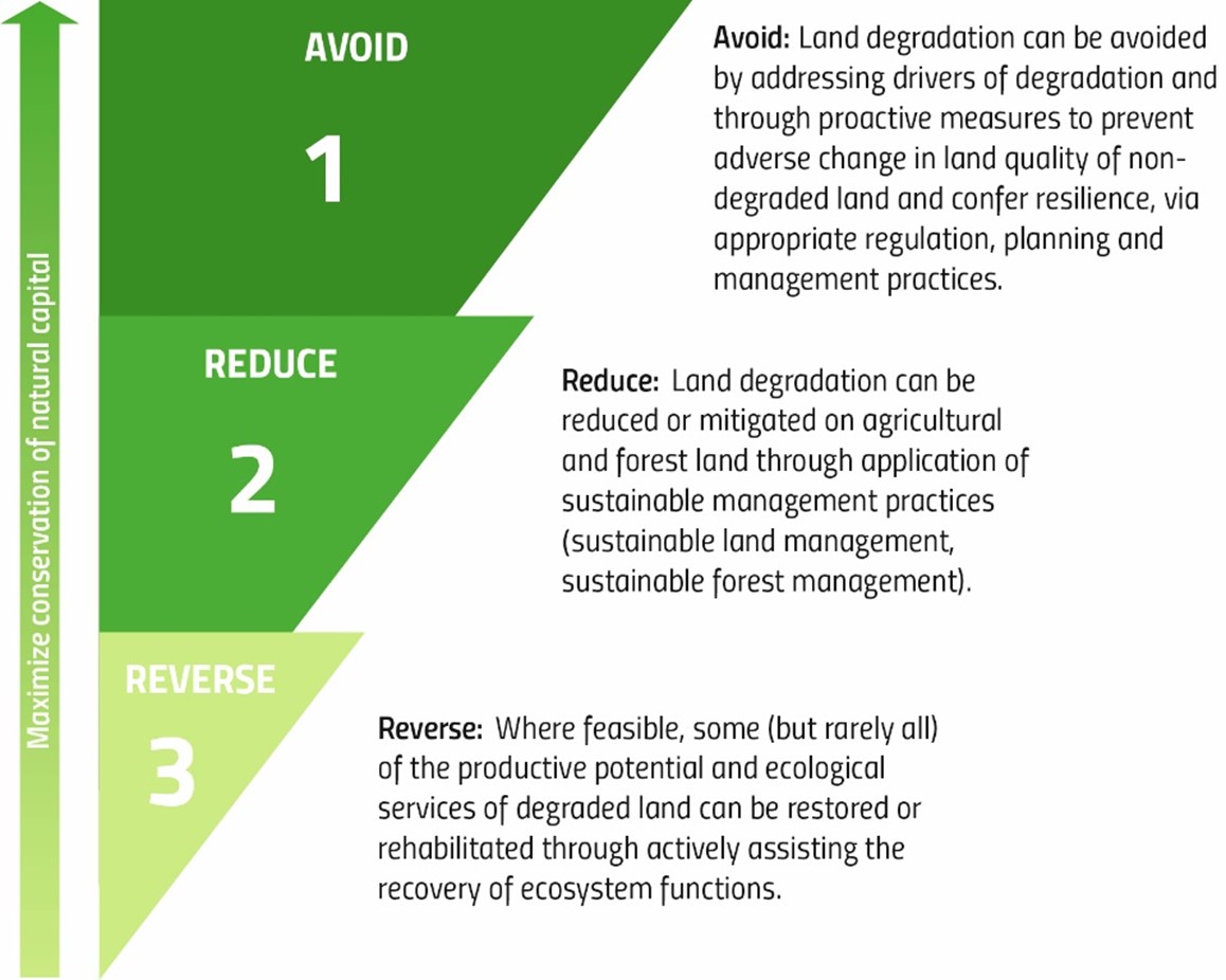
Figure 9. Land Degradation Neutrality response hierarchy
Geographic specificity helps define realistic targets. Spatially explicit targets with distinct locations, ecosystem types and maps can provide increased focus on critical hotspot areas, aid prioritization and help create realistic and purposeful sub-national commitments and plans.
An example of a specific, time-bound, quantitative and spatially explicit LDN voluntary target reported by Colombia in its 2022 national report is: “by 2030, improve pasture coverage in an area of 9,000 Hectares with forest species for the implementation of silvopastoral systems within the jurisdiction of Carsucre (Sucre department)”. In this example, the spatially explicit element of this target was reported via the submission of a polygon/shapefile in the PRAIS4 spatial data viewer.
LDN is intended to be achieved at the national level. Countries typically aim to achieve this through the definition of a combination of national target(s) and complementary targets at the sub-national level for a specific indicator and/or a specific geographic area (i.e., a particular ecosystem, natural area, watershed or subnational administrative jurisdiction), which together contribute to meeting Parties’ ambitions in achieving or exceeding LDN at the national level. Some examples of LDN targets from the 2022 national reporting at different levels of application are presented in table 22.
Level of application |
Example |
|---|---|
National level (no net loss) |
“Achieve Land Degradation Neutrality (LDN) by 2030 compared to the 2019 baseline” |
Sub-national level |
“By 2030, the extent of tree-covered areas in the Barbados National Park has increased by 10 % relative to the 2019 baseline” |
Specific target (to avoid land degradation) |
“By 2030 in Georgia protected areas coverage should reach 12%” |
Specific target (to reduce land degradation) |
“In areas identified as hotspots in Somalia by 2030 improve land productivity on 33,342 ha of Tree-covered areas, 472,227 ha of grassland, 7709 ha of cropland currently showing stressed productivity through sustainable land management practices.” |
Specific target (to reverse land degradation) |
“In the Kedougou region of Senegal over the period 2020-2035, 1,348.27 km2 of marginal areas (artificial areas, bare land, and other domains) will be restored and sustainably managed.” |
Voluntary targets and actions undertaken to address land degradation can simultaneously contribute to climate change mitigation and adaptation, biodiversity conservation and multiple Sustainable Development Goals (SDGs). Thus, there is considerable potential for synergies and it is very important that LDN targets ensure policy coherence and alignment with other national commitments made under different Conventions and related initiatives (i.e., Nationally Determined Contributions, National Adaptation Plans, National Biodiversity Strategies and Action Plans, land restoration commitments). In this context, LDN targets should be seen as an effective means of complementing and strengthening other country commitments and avoiding duplication of efforts.
6.1.2. Prerequisites for reporting
An in-depth reading of the LDN Target Setting technical guide.
Familiarity with Section 2 of the Addendum to Good Practice Guidance for SDG Indicator 15.3.1: Proportion of land that is degraded over total land area.
A pool of national experts that report across various Conventions and related initiatives to ensure alignment and coherence between LDN-relevant national commitments and targets.
A spatial data file of the target areas or a good understanding of the location and extent of the targets, allowing them to be reported on in a spatially explicit manner using the PRAIS 4 spatial data viewer.
6.1.3. Reporting process and step-by-step procedure
The step-by-step procedure for reporting is as follows.
Step 1. Declare national voluntary targets
National Voluntary Targets are pre-filled for Parties using the latest information previously reported to the UNCCD through any of the following processes:
PRAIS 4 (national reporting in 2022),
Second Phase of the LDN Target Setting Programme (LDN TSP 2.0),
The LDN Target Setting Programme (LDN TSP),
PRAIS 3 (national reporting in 2018),
LDN Pilot Project.
Changes, updates or additions to the pre-filled information on these targets will supersede the existing information and be considered official once submitted.
The SO1 Voluntary Targets form (SO1-VT) can be found under the SO1 main tab of the PRAIS 4 platform. National voluntary targets are reported in table SO1-VT.T1.
Parties have three options if there is pre-filled target information in their national report:
Edit the existing target using the ‘Revise’ button and provide comments in the ‘Revision text’ field after editing imported targets to explain why a previously reported target has been changed; This can be the case for targets that remain valid and for which a country may wish to increase its level of ambition (e.g., by increasing the number of hectares, or reducing the deadline of achievement), or to simply update its formulation (e.g., if a target aimed to increase forest cover by 20%, and a 5% increase has already been achieved by the time of reporting, the target can now be revised to reflect the remaining 15% increase and reported accordingly);
Add a new unreported target using the ‘Add New’ button at the end of the table;
Remove the existing target if it is considered no longer applicable using the ‘Remove’ button in the last column of the table.
For any new unreported target, Parties are invited to complete as comprehensively as possible all the fields in table SO1-VT.T1. Parties should also select in the drop-down menu of this table the ‘Level of Application’ of the reported target, i.e. if it is a national or subnational target. If reporting a national target (e.g. “Achieve Land Degradation Neutrality (LDN) by 2030 compared to the 2015 baseline”), the ‘Total target area’ field will be disabled since it is assumed the target has national coverage. Also, Parties are not required to report geospatial information if the target has national application.
Table SO1-VT.T1 is a spatial table and therefore should ideally be completed with the support of the Geographic Information System (GIS) tools available in PRAIS 4. The PRAIS 4 spatial data viewer enables Parties to delineate the location and extent of their subnational targets, thereby making them spatially explicit, or to upload an existing spatial file (in vector format) of the target areas. While this is an additional and optional element, it is recommended since such location-based information strengthens spatial approaches to sustainable land management and helps integrate responses to land degradation at the landscape scale, strengthen monitoring and reporting efforts and inform future prioritization of investments for implementation activities.
For example during the 2022 reporting, Bhutan declared one of its LDN targets as the implementation of sustainable land management (SLM) in an area of 35 Km2. Polygons representing the three administrative units concerned were uploaded to PRAIS and are also included in Bhutan’s LDN DSS. Türkiye has also implemented a LDN DSS. For example in one microbasin in the east of the country 34% of the croplands showed declining land productivity trends, indicating ongoing degradation processes. To counterbalance anticipated losses of natural capital, different cropland parcels were prioritized within the micro basin to implement SLM practices to reverse, reduce and avoid land degradation. For example, in 44 ha, crop rotation with certified chickpeas and wheat was introduced. This and other mapped areas were uploaded as spatially explicit voluntary targets to PRAIS 4 during the reporting process.
Additional information not included in the table may be reported in the “General Comments” field at the bottom of the form.
Step 2. Describe implemented actions relevant to the targets
Areas of implemented action (projects and initiatives on the ground) related to the targets can be reported on in table SO1.IA.T1.
If Parties already reported implemented actions in PRAIS as part of their 2022 national report, they will be pre-filled in this table.
As in SO1-VT.T1, Parties have the same three options to manage the existing implemented actions in the reporting form (i.e. edit, remove or add new implemented actions).
Ideally the implemented actions should correspond to specific targets declared in SO1-VT.T1. However Parties can report new implemented actions that are not specifically addressing an existing SO1 voluntary target.
When reporting a new action or editing an existing one, the actions should be described, their location presented, as well as the start date for the action and the areal extent (in km2). In addition, the source of funding to implement the action should be described using one of the options presented in the dropdown menu. As this is a new field, Parties should update actions previously reported with the source of funding (if applicable). As for Step 1, subnational areas of implemented action should ideally be delineated in the PRAIS 4 spatial data viewer.
Delineating voluntary targets and related actions currently under implementation can help track progress towards achieving LDN in a country by 2030, support the quantification of any remaining gaps and develop scenarios for closing those gaps. In addition, the UNCCD can use this spatial data to create information products to demonstrate the impact of the Convention and global progress towards LDN.
Step 3. Save form and make available for review
Parties have the option to include additional information in the ‘General Comments’ field to add any relevant information or to report on specific country or regional situations.
Once the form has been completed and verified by the Parties, it should be marked as “In Review” and saved. Once the UNCCD has completed its review and any review comments have been resolved by the Parties, the form can be marked as “Finalized” and saved.
6.1.4. Dependencies
Although there is no direct dependency between the voluntary targets and SO 1 indicators, it is expected that the results of the geospatial analyses for the estimation of the proportion of degraded land will inform the definition and spatial delineation of the voluntary targets and related projects and initiatives on the ground.
There is a dependency between the targets set in table SO1-VT.T1 and the implemented actions reported in SO1.IA.T1; each reported action in table SO1.IA.T1 should correspond to one or more targets reported in SO1-VT.T1. However, Parties can still report actions with no link to an existing voluntary target.
6.1.5. Challenges
National coordination
With respect to the various plans and commitments formulated under the Rio Conventions and/or other related initiatives, there is the risk of lack of coherence, overlap and duplication of efforts. There is scope for better alignment on restoration in national plans between the three Rio Conventions, which could enhance planning and implementation.
National voluntary targets need to be well-defined, measurable and time-bound to monitor progress. The availability of GIS tools in PRAIS 4 may support the definition of more accurate and realistic targets in defined locations.
6.1.6. Additional Resources
Achieving Land Degradation Neutrality at the Country Level: Building Blocks for LDN Target Setting (https://www.unccd.int/publications/achieving-land-degradation-neutrality-country-level-building-blocks-ldn-target-setting)
Goals and Commitments for the Restoration Decade. A global overview of countries’ restoration commitments under the Rio Conventions and other pledges. © PBL Netherlands Environmental Assessment Agency, The Hague, 2020, PBL publication number: 3906 (https://www.pbl.nl/sites/default/files/downloads/pbl-2020-goals-and-commitments-for-the-restoration-decade-3906.pdf)
Global Ambition for Land Restoration Report – 2024 (https://grih.info/reports/)
6.2. Voluntary targets for strategic objectives 2, 3 and 4
6.2.1. Introduction
Parties may wish to set national voluntary targets that contribute to the achievement of SOs 2, 3 and 4:
SO 2: to improve the living conditions of affected populations;
SO 3: to mitigate, adapt to, and manage the effects of drought in order to enhance resilience of vulnerable populations and ecosystems;
SO 4: to generate global environmental benefits through effective implementation of the UNCCD.
The definition of voluntary targets should be based on best available data and knowledge. The assessment and estimation of the related indicators can play a key role in informing the decision-making process.
Targets need to be measurable to monitor progress. Parties are invited to formulate quantifiable, time-bound and, where relevant, geographically explicit targets.
Voluntary targets and actions undertaken to achieve the UNCCD SOs can simultaneously contribute to climate change mitigation and adaptation, biodiversity conservation and multiple SDGs. Thus, there is considerable potential for synergies and it is very important that targets set under the UNCCD ensure policy coherence and alignment with other national commitments made under the SDGs, different Conventions and related initiatives.
6.2.2. Reporting process and step-by-step procedure
The step-by-step procedure for reporting is as follows.
Step 1. Declare national voluntary targets
The Voluntary Targets form can be found under the main tab for each of the SOs (2,3,4) of the PRAIS 4 platform. Parties are invited to articulate, in quantifiable and time-bound terms, voluntary targets that contribute to the achievement of SOs 2, 3 and 4, and to include information on the expected year of achievement or actual year (if already achieved), the level of application (e.g., national, sub-national) and the implementation status (achieved, not achieved, ongoing, extended or postponed, partially achieved). Parties should also identify and rank the top five SDGs with which each target aligns (SDG policy coherence).
Spatially delineating the SO 2, 3 and 4 target areas in PRAIS 4 is not requested at this stage. However, geographically explicit targets with distinct locations can help create realistic and purposeful sub-national commitments and plans.
Step 2. Provide any complementary information
Complementary information may be reported in the “General Comments” field. This may include whether the targets have been adopted or officially endorsed and if so, by which body (institution, government agency, regulation). Implemented actions, such as target-related projects and initiatives on the ground can also be described.
Furthermore, Parties are encouraged to outline the linkages with the SDGs, indicate opportunities to create leverage and synergies with their countries’ socio-economic, climate change and biodiversity agendas, and collaborate with other multilateral environmental agreements.
Step 3. Save form and make available for review
Once the form has been completed and verified by the Parties, it should be marked as “In Review” and saved. Once the UNCCD has completed its review and any review comments have been resolved by the Parties, the form can be marked as “Finalized” and saved.
6.3. Additional Indicators
6.3.1. Introduction
Additional indicators at the national and sub-national levels can assist in both interpreting and understanding the common global indicators associated with each strategic objective, and address locally-relevant issues.
6.3.2. Reporting process and step-by-step procedure
The step-by-step procedure for reporting is as follows.
Step 1. Report any national additional indicators
Countries are encouraged to identify complementary indicators for SOs 1 to 4 to better address national and sub-national specificities. These can be additional progress indicators or process indicators to monitor whether actions are being implemented as planned. Additional indicators can be quantitative and qualitative.
While sex-disaggregated data related to exposure of population to land degradation and drought are now collected through indicators SO 2-3 and SO 3-2, Parties are encouraged to identify further gender-responsive socio-economic and demographic indicators that may provide a better understanding of how and why specific populations are affected by land degradation and drought.
Additional indicators can be added on the PRAIS 4 platform via a dedicated form (referred to as AI for brevity in PRAIS 4). The form can be found on the overview page or on the main banner of the PRAIS 4 platform after the SO5 tab. Parties may specify the name of the indicators, the associated SOs and their direction of change. They may also add additional information such as an image representing a map or a chart visualizing the indicator. The type of image won’t be verified automatically by the PRAIS system. The images added will be displayed in the Appendices of the National Report with footnotes mentioning them in the Additional Indicators national report section. A brief description of the indicators, any images uploaded and other relevant information may be reported in the “Comments” field. Metadata describing the dataset used to calculate the additional indicator can be reported by completing the fields (i.e., data source title, author, etc.) provided in the table. One set of metadata can be provided per additional indicator reported.
Complementary information may be reported in the “General Comments” field.
Step 2. Save form and make available for review
Once the form has been completed and verified by the Parties, it should be marked as “In Review” and saved. Once the UNCCD has completed its review and any review comments have been resolved by the Parties, the form can be marked as “Finalized” and saved.
6.4. Affected Areas
6.4.1. Introduction
By its decision 11/COP.14, the Conference of the Parties requested the secretariat to further facilitate reporting on SOs 1, 2, 3 and 4 by, inter alia, including additional data fields specific to affected areas in the reporting system.
Therefore, PRAIS 4 facilitates countries that wish to report on affected areas as an additional and optional item to national reporting. Parties have the option to report on affected areas using a specific set of forms for SOs 1, 2, 3 and 4. The process, forms and tables to report on affected areas are the same as those used for national reporting. No default data is made available for affected area reporting. All spatial data analysis must be carried out outside the PRAIS platform, using Trends.Earth or another spatial data processing tool. If the analysis is done in Trends.Earth, Parties should check the appropriate box within the tool to enable automatic upload of the data to the PRAIS reporting platform.
6.4.2. Prerequisites for reporting
Sub-national data specific to affected areas.
6.4.3. Reporting process and step-by-step procedure
The step-by-step procedure for reporting is as follows.
Step 1: Define affected areas
Parties wishing to report on affected areas are invited to specify the affected area definition in use in their country. In PRAIS 4, Parties may opt to use the definition of the affected areas contained in Article 1 of the Convention[1], or to provide the operational definition of affected area in use in their country.
Once this part of the form has been completed and saved, the reporting forms for SOs 1 to 4 specific to affected areas (referred to as AA for brevity in the reporting forms) will become available in the main banner of the PRAIS 4 system. These forms will not contain pre-filled default data as provided for national reporting. Therefore, Parties will be required to produce the data specific to affected areas and report it in the forms as explained in Steps 2–3.
Step 2: Delineate affected areas
In order to calculate the indicators for affected areas using geospatial information, Parties will be required to spatially delineate the area that corresponds to the definition provided in Step 1 above. This has to be conducted outside of PRAIS. Digitization tools in any GIS software (e.g., ArcGIS, QGIS) could be used for this purpose or Parties may have an existing spatial file of the affected area available (e.g., ESRI shapefile, GeoJSON or any widely accepted file format) which they can upload to Trends.Earth.
Step 3: Calculation of affected area estimates for all indicators
Using the geospatial data of the affected area produced in Step 2, Parties should calculate affected area estimates of all indicators for SOs 1 to 4.
Trends.Earth can be used to run these calculations on the affected area defined. When calculating the indicators in Trends.Earth, Parties should upload the geospatial data of the affected area produced in Step 2 and use it as the area of analysis. Parties should refer to the Trends.Earth documentation for further information on how to use their own area file in the calculations. Once the indicators have been calculated in Trends.Earth and are ready for packaging for upload to PRAIS, Parties should ensure that the checkbox indicating the results are for Affected Areas only is ticked in Trends.Earth. This will ensure that when the results are uploaded to the PRAIS platform the results will automatically populate the Affected Area forms. However, any uploaded geospatial information for affected areas will overwrite any existing national data in PRAIS. Parties may also manually fill in the affected area forms with the required information.
For non-geospatial indicators (e.g., SO2-1, SO2-2, SO4-2 and SO 4-3), Parties may wish to assess the availability of sub-national information specific to the affected areas defined in Step 1, and report it in the forms provided.
Step 4: Save forms and make available for review
All forms and tables on the PRAIS 4 platform for reporting the affected areas should be filled in and supporting data and information provided, if desired, through the upload tools in PRAIS.
Similar to the main national reporting sections, the completed and verified forms should be marked as “In Review” and then saved. Once the UNCCD has completed its review and all comments have been resolved, the form can be marked as “Finalized” and then Saved.
6.4.4. Challenges
Data availability and quality
Depending on the extent of the affected areas, spatial resolution of global default datasets available in Trends.Earth might not always be suitable to calculate indicators with enough sensitivity to spatial variation at sub-national level. Although higher spatial resolution data might be needed, Parties might be challenged by access to commercial satellite imagery, for example, where costs might be prohibitive.
Methodological approach
Affected area definitions may vary across countries, limiting the comparability of results across regions and/or globally.
6.4.5. Summary (main actions)
Key actions for reporting on affected areas are as follows:
Define affected areas: Parties should specify the affected area definition in use in their country.
Delineate affected areas: Parties should spatially delineate the area that corresponds to the definition provided in Step 1 outside of the PRAIS platform.
Calculation of affected area estimates for all indicators: using the spatial data of the affected area produced in Step 2, Parties should calculate affected area estimates for all indicators ideally in Trends.Earth.
Save forms and make available for review: After completion and verification, the forms should be marked “in review” and saved.